Guilin karst is probably the only landscape in the world that appears on a country’s currency — and that you can actually stand in front of, banknote in hand, for a side-by-side comparison.
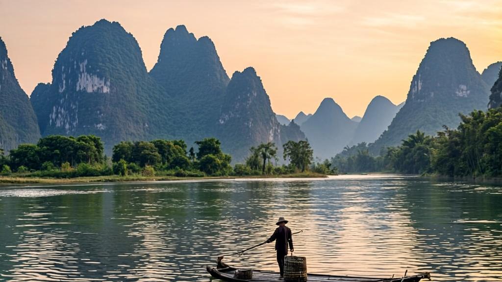
Flip a Chinese 20-yuan note over. The scene on the back shows a lone fisherman on a bamboo raft. Misty limestone towers rise from calm green water. The reflection is almost too perfect to be real. That view exists. It sits near Xingping Town along the Li River, about 60 kilometers south of Guilin city. Tourists go there specifically to recreate the image. But beyond the photo op, there’s a question most visitors never think to ask: how did those mountains get there? And why do they look like that, nowhere else on Earth quite matches this shape?
What Makes Guilin Karst Different From Every Other Mountain
At first glance, a Guilin peak looks almost like a mistake. The towers rise almost vertically from flat rice paddies, with no foothills, no gradual slope — just a sudden wall of limestone shooting straight up, then stopping. That profile is not what mountains typically look like. In the Alps or the Rockies, peaks have shoulders. Here, there are none.
This specific shape has a name. Geologists call it fenglin (峰林), meaning “peak forest.” The International Union of Geological Sciences (IUGS) officially designates Guilin karst as the world’s definitive example of continental fenglin tower karst (IUGS, 2024). That means that when scientists anywhere need to define what tower karst looks like, they reference Guilin.
For comparison, Vietnam’s Ha Long Bay also has karst. So does Thailand’s Phang Nga Bay and Slovenia’s Škocjan Caves. However, none of them match Guilin’s form. Ha Long Bay’s formations rise from the sea and lean slightly. Guilin’s towers rise from river plains and go nearly vertical. The difference comes down to what happens at the base of the limestone — specifically, whether lateral erosion by rivers or vertical infiltration by groundwater does the main work. In Guilin, both forces operated simultaneously over an exceptionally long time.
400 Million Years in Thirty Seconds
Here’s the short version of a very long story.
Around 400 million years ago, the land where Guilin now sits was a shallow sea near the equator. Marine organisms died, sank, and compressed into thick layers of limestone. Over time, the seafloor rose. Eventually it became land. The limestone that had been quietly deposited under water started getting attacked from above — by rain.
Rain is weakly acidic. When it picks up carbon dioxide from the atmosphere, it forms carbonic acid. That acid dissolves limestone slowly but relentlessly. Over hundreds of millions of years, the Guilin basin sat at a relatively low altitude compared to the surrounding hills. Water collected there. Lots of it. The seasonal monsoon brought even more. The result was an unusually aggressive cycle of dissolution — water carving through a 3,000-meter-thick succession of Upper Devonian to Lower Carboniferous limestone (IUGS, 2024).
In the Quaternary period, differential tectonic uplift added another layer of complexity. Some sections of the landscape rose faster than others. Where slower uplift and abundant alluvial cover met, the fenglin tower karst took hold — isolated peaks rising from flat, limestone-floored plains. The surrounding softer material dissolved away. The harder cores remained. Standing straight up.
Why Geologists Call This the “Guilin Model”
The phrase “Guilin model” turns up in actual scientific literature. It describes a specific pattern of karst evolution — where fengcong (cone karst, with connected bases) gradually evolves into fenglin (tower karst, with isolated peaks) as surface lowering continues over time (Waltham, 2009).
Basically, what you see in Guilin is the end stage. The limestone has been eroding for so long, and the flat plains have been lowering for so many millions of years, that the connections between the peaks dissolved away. The result is a landscape that looks almost architectural — like towers placed deliberately on a flat surface.
For anyone who has visited the Dolomites, the Black Hills, or even the Yorkshire Dales, the contrast is striking. Those landscapes have karst features too. But they never reach this level of isolation and verticality. The warm, wet subtropical monsoon climate of southern China is the key difference. More rain, more carbonic acid, more dissolution, over a much longer uninterrupted period.
The UNESCO and IUGS Recognitions — Why They Both Matter
Guilin karst carries two distinct international designations, and they recognize different things.
In 2014, UNESCO added Guilin to the South China Karst World Heritage Site. The South China Karst property now covers 97,125 hectares across seven clusters in four provinces. UNESCO describes it as “unrivalled in terms of the diversity of its karst features and landscapes” (UNESCO, 2024). The Guilin component specifically earns recognition for its “internationally acclaimed fenglin riverine landscapes.”
Then, in August 2024, the International Union of Geological Sciences (IUGS) added Guilin karst to its World Geological Heritage Site list — the second batch of 100 globally. The IUGS distinction focuses on scientific significance rather than aesthetic value. Guilin made the list because of the “Guilin model’s” importance to global karst research, not just because it looks beautiful (IUGS, 2024).
So: two separate international bodies, two separate sets of criteria, same conclusion.
Standing at the Banknote Spot — Practical Notes for Visitors
The specific viewpoint on the 20 yuan note is located near Xingping Town, Yangshuo County. More precisely, it captures the “Reflection of Yellow Cloth Shoal” (黄布倒影, Huángbù Dàoyǐng), a stretch of the Li River south of Nine-Horse Fresco Hill.
A few practical details worth knowing:
- The viewpoint itself is free to access. Parking is restricted near the site, so plan to park roughly 500 meters away and walk (Airial Travel, 2026).
- Sunrise and sunset give the best conditions. The mist that makes the scene look like a painting tends to form in cooler morning air or evening humidity.
- The Li River cruise from Guilin to Yangshuo passes directly through this stretch. The full cruise takes around four hours and covers roughly 83 kilometers of fenglin landscape from above water.
- Bring the actual banknote. Yes, it sounds obvious. But the side-by-side comparison at the viewpoint is genuinely satisfying — and provides an instant sense of scale that no photo can quite replicate.
Beyond Xingping, the broader Guilin karst region rewards slower travel. Yangshuo to the south offers bamboo rafting on the Yulong River, cycling through fenglin plains, and villages surrounded on all sides by towers. The cave systems — including Reed Flute Cave (芦笛岩) inside the city — extend the geological story underground, into chambers full of stalactites that started forming when the surface towers were still being carved.
A Note on the Western Parallel
The word “karst” itself comes from the Karst region of Slovenia, along the Adriatic coast. That area gave geologists their original reference point for limestone dissolution landscapes in the 19th century. Slovenian and Croatian karst features — including the famous Postojna Cave and the Škocjan Caves UNESCO site — are impressive.
However, when European geologists first encountered the Guilin landscape, they recognized that their existing vocabulary needed expanding. The term “tower karst” was created specifically to describe what they found here. Guilin didn’t fit the European model. It exceeded it. As geologist Tony Waltham noted, the fenglin of the Guilin-Yangshuo region is “the definitive example” of this landform type, and its full development elsewhere in the world is extremely limited (Waltham, 2009).
In a certain sense, China got to name a type of landscape. The rest of the world just visits it.
References
International Union of Geological Sciences (IUGS). (2024). Guilin Karst — World Geological Heritage Site. https://iugs-geoheritage.org/geoheritage_sites/guilin-karst/
UNESCO World Heritage Centre. (2024). South China Karst (Property No. 1248). https://whc.unesco.org/en/list/1248/
Wikipedia. (2026). South China Karst. https://en.wikipedia.org/wiki/South_China_Karst
Waltham, T. (2009). The karst lands of southern China. Geology Today, 25(6), pp. 234–240. https://onlinelibrary.wiley.com/doi/full/10.1111/j.1365-2451.2009.00736.x
Airial Travel. (2026). 20 Yuan Note Viewpoint Xingping. https://airial.travel/attractions/china/gui-lin-shi/20-yuan-note-viewpoint-xingping-5gkGnUbt
China Odyssey Tours. (2025). Sceneries on RMB Banknotes. https://www.chinaodysseytours.com/special-topic-about-china/sceneries-on-rmb-banknotes.html
Zhu, X.W. (1991). New Considerations on the Characteristics and Evolution of Tower Karst. Carsologica Sinica, vol. 10, no. 1–3, pp. 51–182.