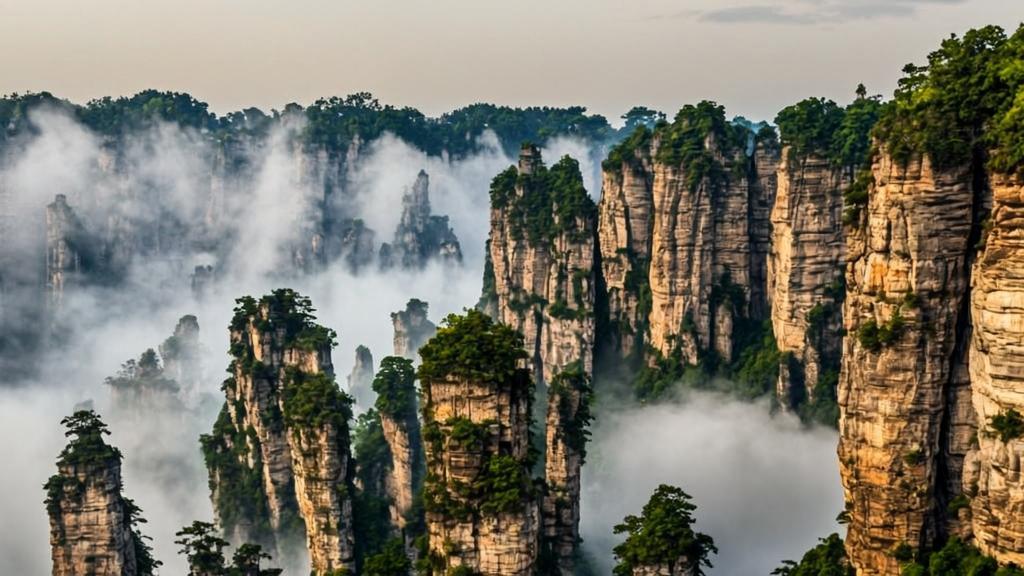
Wulingyuan doesn’t look real. That’s not an exaggeration — it’s precisely why James Cameron used it.
When the director of Avatar was designing the floating Hallelujah Mountains of Pandora, he drew from landscapes around the world. But one place stood out most clearly: the towering quartzite sandstone pillars of Wulingyuan in China’s Hunan Province. In January 2010, the park’s most iconic peak — the 1,080-meter Southern Sky Column — was officially renamed the “Avatar Hallelujah Mountain” in honor of the film (Wikipedia, Zhangjiajie National Forest Park, 2025).
Yet most visitors who travel to Wulingyuan to see the “Avatar mountains” leave without understanding why this landscape exists at all. The geology here is not just visually extraordinary. It tells a story spanning more than 380 million years. And it turns out that story is, if anything, more dramatic than anything Cameron invented.
Wulingyuan Scenic Area: The Numbers First
A few basic facts. Wulingyuan Scenic and Historic Interest Area was inscribed as a UNESCO World Heritage Site in 1992. It covers more than 26,000 hectares in northwestern Hunan Province. The park contains over 3,000 individual quartzite sandstone pillars. Many rise more than 200 meters above the valley floor. Some exceed 400 meters.
In 2004, it was additionally listed as a UNESCO Global Geopark — one of a small number of sites worldwide recognized for both exceptional heritage value and outstanding geological significance (UNESCO World Heritage Centre, 1992).
That dual UNESCO status is not ceremonial. Wulingyuan’s geology is so distinctive that scientists have proposed formally naming this type of landscape after the site itself: the “Zhangjiajie Landform.” There is nowhere else on earth with quite the same combination of rock composition, erosion history, and vertical scale.
380 Million Years, Step by Step
Understanding Wulingyuan means going back — very far back. Here is the geological sequence, simplified but accurate.
Step 1: The ancient sea (380 million years ago). Northwestern Hunan was once a shallow ocean. Over millions of years, rivers carried enormous quantities of terrigenous sediment — sand, gravel, and loose clastic rock — into this sea. Layer by layer, the material settled on the ocean floor (Zhangjiajie Tour Guide, n.d.).
Step 2: Compaction into hard stone. Under intense pressure and heat, those sediment layers fused together into dense quartz sandstone. The quartz content in Wulingyuan’s rock measures between 75% and 95% — exceptionally high. That’s what makes the stone so resistant to the erosion that shapes softer rock into ordinary hills (Quora geological analysis, n.d.).
Step 3: Tectonic uplift (beginning approximately 70 million years ago). The same vast tectonic forces that built the Himalayas pushed this region upward from below sea level. What had been a flat ocean floor became dramatically elevated terrain. Flat high-level erosional surfaces formed at the tops of the rising stone — the ancestors of today’s ridge platforms (Zhangjiajie Tour Guide, n.d.).
Step 4: Joint fracturing. As the rock rose and was subjected to new pressures, vertical cracks — called joints and fissures — formed throughout the sandstone. These fractures ran primarily in two intersecting directions, creating a natural grid pattern across what had been a solid plateau. Water, ice, gravity, and time then began exploiting every crack they could find.
Step 5: Millions of years of physical erosion. Rainfall in subtropical Hunan is abundant. Water found the joints. During freeze-thaw cycles, ice forced the cracks wider. Softer material eroded away. The harder, quartz-rich cores held. Over millions of iterations of this process, a broad sandstone plateau was carved into thousands of individual vertical columns of extraordinary variety in height and form.
Crucially, this is physical erosion — not the chemical dissolution that creates limestone karst landscapes. The mechanism at Wulingyuan is genuinely different, which is exactly why the result looks different from anything else on earth.
Why It Looks Like It’s Floating
The “floating” quality that Cameron captured so memorably in Avatar has a specific explanation. The pillars stand on relatively narrow bases, surrounded by deeply carved valleys. Dense subtropical vegetation grows on their tops and sides. When morning fog or post-rain mist fills the low-lying valleys — which happens frequently in Hunan’s humid climate — only the upper portions of the pillars remain visible above the white.
This is not CGI. It happens on ordinary mornings, often lasting for an hour or two after sunrise. The mist settles in the gorges. The peaks emerge above it. The visual logic of floating mountains becomes, briefly, completely convincing.
Stand there for five minutes during such conditions and you’ll experience something that no photograph fully captures: the mist shifts. Pillars appear and disappear. The landscape repaints itself continuously. It is, as one visitor wrote, like watching a Chinese ink landscape painting develop in real time — then erase and start again.
Comparing Wulingyuan to Western Geological Wonders
Western visitors often reach for comparisons from their own experience. The Grand Canyon is the most common reference. Both Wulingyuan and the Grand Canyon involve dramatic vertical rock formations shaped over millions of years. Both are protected heritage sites. Their scale defies easy photography.
But the experience is fundamentally different. The Grand Canyon is primarily horizontal — a vast, wide chasm cut downward by a river through layered rock. Its drama is in depth. You look down.
Wulingyuan is vertical. You look around and up. Thousands of separate columns rise from the forested valley floor, each individually distinct, each topped with its own small community of trees and plants. The Bryce Canyon in Utah offers a partial comparison — hoodoos, slender rock spires formed by similar freeze-thaw erosion. But Bryce Canyon’s pillars are limestone and fragile; Wulingyuan’s are quartzite and on a scale roughly ten times larger.
Norway’s fjords share a certain awe-inspiring verticality. But fjords are carved by glaciers into U-shaped valleys. Wulingyuan’s landscape was carved by water into thousands of separate upright towers. The mechanism, the scale, and the visual result are all different.
The Wulingyuan That Visitors Don’t Expect
Most first-time visitors focus on the famous viewpoints — Yuanjiajie and its Avatar Hallelujah Mountain, Huangshizhai’s panoramic ridge, the Ten Mile Gallery. These are genuinely extraordinary.
But Wulingyuan’s less-photographed features deserve attention too:
- Bailong Elevator — at 326 meters, the world’s tallest outdoor elevator, carrying visitors from valley floor to ridge in under two minutes (Wikipedia, Zhangjiajie, 2025)
- Tianqiashengkong natural bridge — one of the highest natural rock bridges in the world, crossing a valley at nearly 300 meters elevation
- Yellow Dragon Cave — a massive cave system with calcite formations covering 2.8 square kilometers
- Golden Whip Stream (Jinbianxi) — a 7.5-km forest walk along a clear stream, surrounded by pillars on both sides, consistently rated among the most scenic walks in China
The park is also, unexpectedly, excellent for wildlife. It provides habitat for the Chinese giant salamander, Chinese water deer, Asiatic black bear, and dhole (UNESCO, 1992). These are not commonly encountered by visitors, but their presence is a reminder that Wulingyuan remained largely isolated from human activity until its “discovery” in 1979.
Visiting Wulingyuan in 2025–2026: What You Need to Know
The park is accessible year-round. Spring (April–June) and autumn (September–November) offer the best conditions for visibility and photography. Mist is most reliable in the early mornings after rain — which is actually an argument for staying overnight inside the park rather than commuting daily from Zhangjiajie city.
Practical information:
- Location: Wulingyuan District, Zhangjiajie City, Hunan Province, China
- Nearest airport: Zhangjiajie Hehua International Airport (approximately 40 minutes by road)
- Entry ticket: One ticket covers Zhangjiajie National Forest Park, Tianzi Mountain, Yuanjiajie, and Yangjiajie for four consecutive days
- Visa: As of late 2024, China expanded visa-free transit to eligible travelers from 54 countries for up to 10 days; certain nationalities enjoy 30-day visa-free stays (Asia Odyssey Travel, 2026)
- Payments: Overseas bank cards and digital payments are now widely accepted throughout the park area
In 2025, Wulingyuan welcomed over one million inbound foreign visitors for the first time — a 25% increase year-on-year — from 183 countries and regions (Voice of China, 2026). The park has invested significantly in multilingual signage, English-speaking guides, and international payment systems.
The Landscape That Inspired Before Anyone Arrived
There is something worth pausing on here. The landscape of Wulingyuan is so extreme that a Hollywood blockbuster used it as the template for an alien world — and still added significant CGI to make it appear believable. The actual place is stranger, quieter, and far more patient than any film.
The geological forces that shaped these pillars have not stopped working. The crust beneath Zhangjiajie continues to rise slowly. Erosion continues. The landscape visitors see today will look different in another million years.
For now, it looks like Pandora. But it has been here, in variations of its current form, since long before any camera was pointed at it — and long before any civilization existed to point one.
References
Asia Odyssey Travel. (2026). Wulingyuan National Park: Map, town & scenic area. https://www.asiaodysseytravel.com/zhangjiajie/wulingyuan-national-park.html
China Today. (2019, March 4). Wulingyuan: The mythical land of Avatar is real. http://www.chinatoday.com.cn/ctenglish/2018/tourism/201903/t20190304_800159022.html
National Parks Organization. (2025). Zhangjiajie National Forest Park. https://national-parks.org/china/zhangjiajie/
UNESCO World Heritage Centre. (1992). Wulingyuan Scenic and Historic Interest Area (World Heritage List No. 640). https://whc.unesco.org/en/list/640
Voice of China. (2026, January 15). Wulingyuan sees over one million inbound visits in 2025. https://m.voc.com.cn/xhn/news/202601/31356984.html
Wikipedia. (2025). Wulingyuan. https://en.wikipedia.org/wiki/Wulingyuan
Wikipedia. (2025). Zhangjiajie National Forest Park. https://en.wikipedia.org/wiki/Zhangjiajie_National_Forest_Park
Zhangjiajie Tour Guide. (n.d.). Landform of Zhangjiajie. https://www.zhangjiajietourguide.com/article-p263-landform-of-zhangjiajie.html